Tag: Albania Geology

Specialist Wonderful Albania guide for Albania Geology.

  • Geology of the Albanian Alps: Karst Peaks, Glacial Valleys and Alpine Lakes

    Geology of the Albanian Alps: Karst Peaks, Glacial Valleys and Alpine Lakes

    The Albanian Alps look dramatic because several geological stories overlap in the same small area. High relief exposes limestone ridges and karst caves, while past glaciers deepened valleys and left cirques, troughs and dozens of alpine lakes. Rivers such as the Valbona and Shala then reworked the valley floors with gravel and seasonal flow.
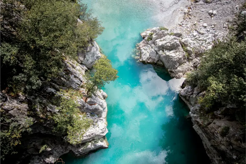
    Aerial Shot Valbona Valley National Park Reflecting Waters Albania

    AKZM describes the Albanian Alps National Park as 82,844.65 hectares and highlights both karstic and glacial relief as defining values. The agency notes roughly 30 glacial lakes grouped around areas such as Gashi, Dobërdol, Sylbicë, Runicë and the Jezercë block. That makes the Alps a superb place to understand geology while doing ordinary travel activities: hiking, village stays, scenic drives and photography.

    You do not need to climb Jezercë to appreciate the geology. Theth, Valbona, Qafë e Thorës, Dragobi and the high pastures all reveal different parts of the same mountain system.

    Quick planning summary

    QuestionPractical answer
    Best beginner baseTheth for easy access to valley scenery, Grunas and Blue Eye hikes.
    Best broad valley viewValbona, where steep peaks frame a wide glacially influenced valley floor.
    Best high-mountain geologyJezercë block, Dobërdol and Sylbicë for experienced hikers.
    Main rock storyExtensive limestone karst combined with strong relict glacial landforms.
    Best seasonLate spring through early autumn for most hiking; winter requires specialist planning.

    A mountain range shaped by karst and ice

    AKZM describes the Alps as Albania’s most mountainous region and emphasizes a dome-like relief with radial ridges and valleys. Limestone karst produces caves, fissures, springs and sharp rock scenery, while glaciation carved cirques and valleys at high elevation. The combination explains why water can disappear underground in one place and erupt as a powerful spring elsewhere.

    The phrase “Albanian Alps” is therefore more than a visual comparison. The landscape genuinely contains alpine geomorphology: steep rock peaks, high cirques, glacial lakes, avalanche tracks and deep valleys that concentrate settlements and roads.

    Theth: a valley where geology is easy to see

    Theth is an ideal first base because geological features sit close to village life. Grunas Waterfall drops through a steep valley setting, the Blue Eye hike leads to a spring-fed pool in rugged limestone terrain, and the surrounding peaks reveal exposed pale rock above forested slopes.

    Walk slowly enough to notice changes underfoot. Valley-floor gravels, spring water, cliff bands and cave entrances each reflect different processes. The famous scenery becomes more interesting when you stop treating every feature as simply “mountain.”

    Valbona: river, gravel and underground flow

    Valbona shows the relationship between a high mountain river and karstic substrate. Official tourism material notes that water can disappear beneath gravel in seasonal sections because of the valley’s karst character. The broad pale riverbed is therefore part of the hydrology, not merely an empty space beside the visible channel.

    The valley is also useful for seeing how steep tributaries deliver rock and sediment from the mountains. After storms, these systems can change quickly, which is why hikers should treat dry channels and gravel fans as active landforms rather than permanent paths.

    Jezercë and the high cirques

    Jezercë rises to 2,694 metres and sits among some of the most rugged terrain in the range. Official tourism material describes deep glacial valleys and steep ridges around the peak. Reaching the summit is a serious mountain objective, but you can understand the high-alpine geology from lower routes and valley viewpoints without climbing it.

    Experienced hikers who go higher should think in terms of terrain rather than destination alone: scree, exposed rock, snow patches, weather and route finding matter. A geological interest is never a reason to push into conditions beyond your skills.

    Caves and karst drainage

    AKZM notes large karst caves in the Alps, including systems extending for kilometres. Dragobi Cave is a more approachable named example in the Valbona area and is protected for geomorphological and speleological value. Caves are evidence that much of the water story happens inside the mountain.

    Most large cave systems are not casual tourist attractions. Do not equate a mapped cave symbol with safe independent access. Professional speleology involves route knowledge, lights, helmets, vertical equipment in some caves and a very different risk profile from hiking.

    Glacial lakes and old ice

    Around 30 glacial lakes are identified across the Albanian Alps by AKZM, with groups around Dobërdol, Sylbicë and Jezercë. These lakes occupy basins related to past glacial erosion and deposition. Their presence helps reconstruct a colder landscape in which ice extended through valleys that are now pasture or hiking terrain.

    For travelers, the lakes are best appreciated as part of multi-day mountain routes. Their remoteness protects their atmosphere but also means that navigation, weather and leave-no-trace behavior matter more than at developed attractions.

    Best time of year

    June through September is the core practical window for most hiking, though snow can persist on high routes and autumn weather can turn quickly. May can be beautiful in lower valleys but high passes may still be affected by snow. Winter transforms the park into a specialist environment; access and avalanche conditions require local expertise.

    Getting there and transport

    Shkodër is the main logistics base. Theth is reached by mountain road and seasonal shuttles; Valbona is commonly combined with the Koman ferry or reached by road via Kosovo-facing northern routes. Do not schedule a tight same-day connection after a major hike. Mountain transport is more resilient when you leave margin for weather and road delays.

    Red Bridge Along River Valbona Valley Theth National Park Albanian Alps Albania

    Safety and responsible geotourism

    The geology itself creates hazards: loose scree below limestone cliffs, sudden drop-offs, hidden karst holes, fast mountain water and snow-filled gullies. Stay on established routes, carry offline navigation and tell someone your plan for longer hikes. Water that looks clear is not automatically safe to drink without treatment.

    Geological sites often look robust because they are made of rock, but caves, spring margins, alpine soils and fossil-bearing outcrops can be surprisingly fragile. Stay on established paths, leave formations in place and avoid scratching, stacking or removing material. In protected areas, the best souvenir is a photograph and a better understanding of the landscape.

    Photography tips

    The best geology photographs often use layered depth: valley floor in the foreground, limestone walls in the middle and high cirques behind. Qafë e Thorës, Valbona valley viewpoints and village approaches are excellent without requiring technical climbs. Cloud can improve texture on pale rock, while midday sun tends to flatten relief.

    Families, senior travelers and accessibility

    Theth and Valbona villages work well for families who choose short walks and avoid ambitious passes. Children can learn to identify waterfall, spring, gravel fan and cliff. Reduced-mobility visitors can still experience the mountain scale from valley roads, guesthouses and scenic stops, though many classic paths are rough and steep.

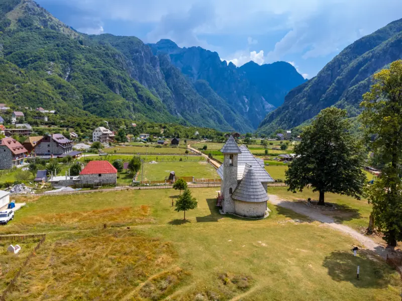
    Aerial View Valbona Valley Theth National Park Albanian Alps Albania

    Where to stay

    For this theme, I would choose accommodation that reduces early driving and makes it easy to ask about current road or trail conditions. Compare places to stay in Shkoder on Booking.com. Check parking, breakfast times and whether the host can recommend a local guide for natural sites.

    Guides and organized experiences

    A knowledgeable local guide can add far more than transport. For caves, canyons, remote mountain terrain and boat-based geology, the useful questions are about current access, water or sea conditions, protected-area rules and realistic turnaround points. Avoid operators who treat safety limits as optional.

    How this fits into a wider Albania trip

    I would keep geology as a thread through the trip rather than the only purpose of every day. Pair a natural site with a historic town, village meal, beach or museum. That rhythm leaves room for weather changes and makes the itinerary enjoyable even for companions who are less interested in rocks and landforms.

    Official sources and further reading

    Official tourism and protected-area pages are useful for geological context, but road surfaces, trail access, boat departures, water levels, parking arrangements and local restrictions can change. Recheck time-sensitive information shortly before travel.

    Frequently asked questions

    Are the Albanian Alps mainly limestone?

    Limestone and karst landforms are major parts of the scenery, but the range is geologically varied. For a traveler, the most visible recurring features are pale carbonate cliffs, caves, springs and glacial landforms.

    Do I need to hike the Theth–Valbona Pass to understand the geology?

    No. Both valleys show glacial relief, river gravels, springs and limestone walls from easier walks and viewpoints. The pass adds a high-level perspective but is not essential.

    Why does the Valbona River sometimes seem to disappear?

    Official tourism material notes that water can sink beneath gravel in karstic sections, especially seasonally. Underground and subsurface flow are part of the valley’s natural hydrology.

    Final planning approach

    The Albanian Alps reward travelers who look at the whole valley, not just the summit. Karst controls where water moves, glaciers explain many of the basin shapes, and modern rivers keep rearranging the valley floors. Once those three ideas are visible, every hike becomes more legible.

    Practical checklist before departure

    • Download offline maps for rural and mountain areas.
    • Check the latest weather for the exact region, not only Tirana.
    • Carry water, sun protection and footwear suitable for uneven rock.
    • Do not enter caves or narrow canyons after heavy rain.
    • Use safe parking and formal viewpoints rather than roadside improvisation.
    • Leave rocks, fossils, cave formations and spring habitats undisturbed.
  • Geology of the Albanian Riviera: Llogara, Çika, Karaburun, Gjipe and Sea Caves

    Geology of the Albanian Riviera: Llogara, Çika, Karaburun, Gjipe and Sea Caves

    The Albanian Riviera is famous for beaches, but the coastline is fundamentally a mountain-and-rock story. The Çika range rises abruptly above the Ionian Sea, Llogara marks a dramatic watershed, Gjipe Canyon cuts through coastal relief and the Karaburun Peninsula exposes limestone that has been fractured, dissolved and eroded by both groundwater and waves.

    Turquoise Beach On The Albanian Riviera

    AKZM’s description of Karaburun-Sazan identifies carbonate rocks, including limestone and limestone-dolomite, alongside flysch and younger deposits. It also notes karst springs and freshwater discharge along the coast. That geology explains the cliffs, sea caves, hidden bays and unusually sharp transition from mountain to sea.

    This guide helps you notice the geology while doing a normal Riviera trip. You can understand most of it from roads, beaches, boat trips and moderate hikes; no specialist fieldwork is required.

    Quick planning summary

    QuestionPractical answer
    Best panoramic geologyLlogara and Mount Çika for the mountain-to-sea relationship.
    Best coastal karstKaraburun Peninsula.
    Best canyon-to-beach exampleGjipe.
    Best sea-cave experienceHaxhi Ali Cave by boat in suitable sea conditions.
    Best baseVlorë for Karaburun; Himarë or Dhërmi for Gjipe and the central Riviera.

    Why the coast is so steep

    Southern Albania’s coast is not a broad lowland beach plain. Mountain blocks rise close to the Ionian shore, and resistant rock forms headlands and cliffs while shorter streams cut steep ravines toward the sea. The road repeatedly climbs and descends because the topography is structurally controlled rather than gently rolling.

    This steepness shapes travel as much as scenery. A beach visible directly below you may require a long descent, a boat or a road that loops far inland. Geology explains why straight-line distance is often misleading on the Riviera.

    Llogara and Mount Çika

    Llogara sits where high mountain terrain overlooks the coast, and Mount Çika rises to about 2,044 metres according to the national tourism authority. The viewpoint relationship is extraordinary: forested pass, pale rock, steep slopes and Ionian water fit within a single panorama.

    For geology, the old pass road and hiking trails are more informative than simply driving through the tunnel. Use safe viewpoints to study the abrupt relief and the way valleys descend toward Palasë and the coast. Do not stop on narrow road edges for photographs.

    Karaburun: limestone, fossils and karst springs

    AKZM describes Karaburun-Sazan as including Upper Cretaceous carbonate rocks with limestone and dolomitic limestone, and mentions fossil components such as rudists and foraminifera. The agency also notes karst groundwater and freshwater springs that discharge along the coast, including below sea level in places.

    For travelers, that translates into pale cliffs, caves, clear water and a rugged coastline with few road accesses. Boat travel is often the best way to read the peninsula’s geometry, because the cliff faces and cave entrances are visible from the sea as continuous landforms.

    Haxhi Ali and wave-cut caves

    Haxhi Ali Cave is the best-known sea cave in the area. Official tourism material describes it as a natural monument formed by marine erosion in limestone. The cave is visually dramatic because wave action has exploited rock weakness at the waterline, enlarging an opening that is now visited by boats.

    Sea-cave access must remain condition-dependent. Swell can make a calm-looking entrance dangerous, and boat captains should decide whether entry is appropriate. Swimming close to rock walls is not automatically safe simply because the water is clear.

    Gjipe: erosion from mountain to sea

    Gjipe Canyon demonstrates the land-to-sea connection beautifully. A short drainage system has incised a steep canyon through coastal rock before opening at the beach. Walking down from the upper access reveals a sequence from dry upland terrain to narrow gorge and marine shore.

    The canyon also explains why beaches here can feel isolated despite being near famous resorts: cliffed terrain restricts road access. That isolation is a geological consequence, not just a tourism branding idea.

    Beaches as sediment stories

    Not every Riviera beach is made of the same material. Pebble size, color and beach shape reflect the local rock supply, wave energy and nearby drainage. A pocket beach enclosed by resistant headlands behaves differently from a long open shore. After storms, the visible sediment can shift significantly.

    Avoid treating a single year’s beach width as permanent. Coastal systems move. This matters when choosing accommodation or planning access to small coves: a beach photographed in calm summer conditions may look very different after winter storms.

    Best time of year

    April to June and September to October are excellent for combining geology with hiking because temperatures are moderate and roads are less congested. July and August favor boat access but bring heat, traffic and crowded beaches. Winter reveals powerful coastal weather but limits marine excursions and can make cliff paths slippery.

    Getting there and transport

    Use Vlorë for Karaburun and Sazan boat logistics, and Himarë/Dhërmi for central-Riviera canyon and beach access. The Llogara tunnel speeds through-travel, while the old pass remains useful for panoramic stops when open and appropriate. Boat routes should be booked according to sea state, not merely the published departure time.

    Albania Riviera Beach Coast Ionian Sea Ksamil Greece Island Corfu Shpella E Pellumbave Beach 2

    Safety and responsible geotourism

    Cliffs, loose rock, heat and sea conditions are the main risks. Do not stand beneath unstable-looking faces, climb unprotected coastal rock for a photo or enter sea caves when the captain advises against it. On hikes such as Gjipe, carry more water than you expect to need and avoid the hottest hours.

    Geological sites often look robust because they are made of rock, but caves, spring margins, alpine soils and fossil-bearing outcrops can be surprisingly fragile. Stay on established paths, leave formations in place and avoid scratching, stacking or removing material. In protected areas, the best souvenir is a photograph and a better understanding of the landscape.

    Photography tips

    The strongest geology images on the Riviera usually include both mountain and sea. A wide view from Llogara shows relief, while boat-level photographs along Karaburun reveal bedding, cave openings and cliff height. Morning and late afternoon give more side light on rock texture; midday is best for water clarity.

    Families, senior travelers and accessibility

    Families can enjoy Llogara viewpoints, beach sediment, short coastal walks and a well-run boat trip. Gjipe’s hike is better for older children comfortable with heat and uneven ground. Reduced-mobility travelers can still experience excellent geology from Vlorë boat trips and selected Llogara viewpoints, though small coves often have difficult access.

    Where to stay

    For this theme, I would choose accommodation that reduces early driving and makes it easy to ask about current road or trail conditions. Compare places to stay in Vlore on Booking.com. Check parking, breakfast times and whether the host can recommend a local guide for natural sites.

    Guides and organized experiences

    A knowledgeable local guide can add far more than transport. For caves, canyons, remote mountain terrain and boat-based geology, the useful questions are about current access, water or sea conditions, protected-area rules and realistic turnaround points. Avoid operators who treat safety limits as optional.

    How this fits into a wider Albania trip

    I would keep geology as a thread through the trip rather than the only purpose of every day. Pair a natural site with a historic town, village meal, beach or museum. That rhythm leaves room for weather changes and makes the itinerary enjoyable even for companions who are less interested in rocks and landforms.

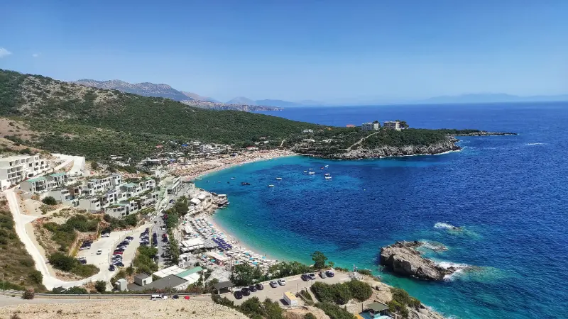
    Jale Beach Bay Albanian Riviera

    Official sources and further reading

    Official tourism and protected-area pages are useful for geological context, but road surfaces, trail access, boat departures, water levels, parking arrangements and local restrictions can change. Recheck time-sensitive information shortly before travel.

    Frequently asked questions

    Why are Riviera beaches often pebbly?

    Beach sediment reflects local rock, short steep drainage systems and wave energy. Many coves receive coarse material from nearby slopes and streams rather than the abundant fine sand typical of large lowland deltas.

    Can I see Karaburun geology without a boat?

    Some views are possible from land, but a boat gives the clearest continuous perspective on sea cliffs, caves and inaccessible bays.

    Is Llogara still worth visiting after the tunnel opened?

    Yes. The tunnel is a transport improvement, while the old pass and national park remain the places for panoramic mountain geology, hiking and viewpoints.

    Final planning approach

    The Riviera becomes far more coherent when you see it as a steep carbonate coast rather than a chain of beaches. Llogara explains the elevation, Karaburun explains the cliffs and caves, and Gjipe shows how short rivers cut directly through the coastal mountains to the Ionian Sea.

    Practical checklist before departure

    • Download offline maps for rural and mountain areas.
    • Check the latest weather for the exact region, not only Tirana.
    • Carry water, sun protection and footwear suitable for uneven rock.
    • Do not enter caves or narrow canyons after heavy rain.
    • Use safe parking and formal viewpoints rather than roadside improvisation.
    • Leave rocks, fossils, cave formations and spring habitats undisturbed.